• Bugs
  • Missing location on the world map in Antarctica

Please, let me try to explain how world map works in Tonfotos. It does not display each and every location on the map, as that would be impossible for large photo collections with hundreds of thousands of events. Instead it groups (clusters) all events into larger ones, and only displays 10-20 of such combined groups on the map at the same time. Location of each group is not a locations of every event, this is average location of several events that are included. Which may turn out to be quite far away from individual locations of some events.

So what is happening in your case is most likely that event was joined to some larger group not that far away, but still a bit off expected location. However, if you will zoom into this area, such as South America, you will see that large groups will start to fall apart into smaller ones. And will continue falling apart the more you zoom it, until it will be split into individual events with more or less precise locations. (More or less, because event itself has location which is average of individual photo locations).

Sorry for a little clumsy explanation. It is much easier to demonstrate than to explain. So please just zoom in and out, and you will get idea immediately.

Please let me know if that resolves your concern.

    Andrey Sorry, no I have 100+ Antarctica pics that show GPS on folders view but do not show on world whether I zoom in or out, new screenshots added to Dropbox shared folder.
    Is GPS checked on rescan?

      KevinG GPS is stored in EXIF section of the file, so if you change it, file checksum gets changed too and Tonfotos will detect it and will re-index file during regular scan. Rule of thumb is - if you see minimap in the File Info panel, that means those coordinates are already in Tonfotos database.

      However, I guess I know what is wrong with Antarctica files, and issue is that Antarctica is the place where normal geometry does not really work 🙁 The distance between two coordinates cannot be correctly extrapolated as euclidian distance, you need to use little bit more difficult equations. And guess what, using Pareto principle, that special use case was left for later, since assumption was, not so many users have photos from north or south pole in their collections. So I guess the time has finally come to get back and update that piece of code. I will add that to the backlog for future releases.

      As always, sample images would help a lot.

      Andrey changed the title to Missing location on the world map in Antarctica.

      KevinG as always, thank you very much for samples! Here’s what I see on my computer:

      All photos appear to be at correct locations here. I did not change anything in the code yet. However, on dropbox there are screenshots that look very different. Can you please check something for me? Can you please click on one of those picture pin that looks way off its actual location and check if this photo is alone in the event, or there are several of them? Or even there might be many events under that pin?

      I think that the core of issue is that there are several photos or even events, and averaging thier locations gives such strange results. However, having only one image I cannot reproduce it here. I would need whole group of photos that form that wrongly located pin.

      I have upload 30 Antarctica pictures, GPS works fine on image but not showing on map.
      Note these have same GPS position as I updated Exif as these were taken before camera added GPS

      I have checked all image pins on world map, none contained these pics

        6 days later

        KevinG I am still having hard time reproducing error you are experiencing. I have downloaded the photos, they have grouped correctly, and their locations on the map look OK to me.

        The only odd thing I can see with samples you provided is this:

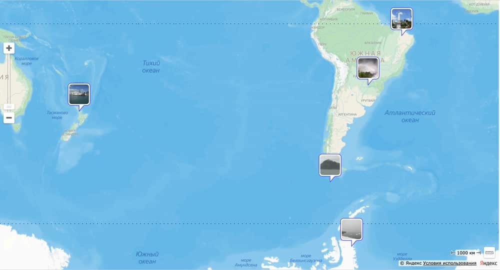
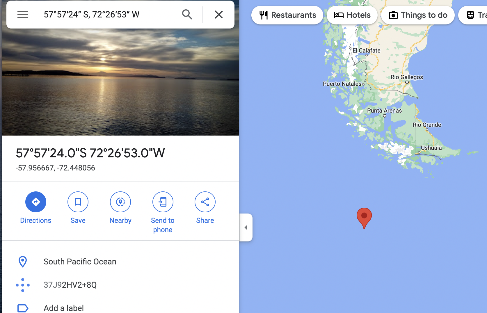
        This picture is indicated as being in the ocean while picture itself obviously shows some land. However, I double checked same coordinates with Google Maps, and it also agrees that this is indeed ocean, not a land. Most likely, there is a mistake in the coordinates in the image itself, but not in the way it is being displayed.

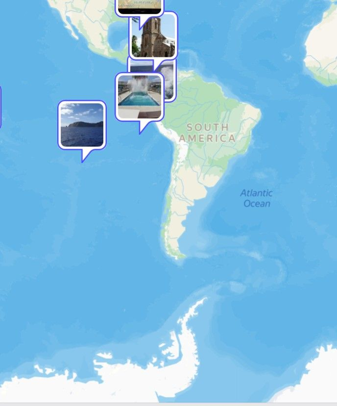
        While it is clear that you are seieng this image in completely different part of the ocean (this is from dropbox):

        To nail down the cause of the issue, we need to isolate all differences between what you are seeing and I see. I propose to focus for a while on that particular image that jumps over different places of the ocean and find why this is happening. Probably that will give us idea what is wrong with other images too. Please do following steps.

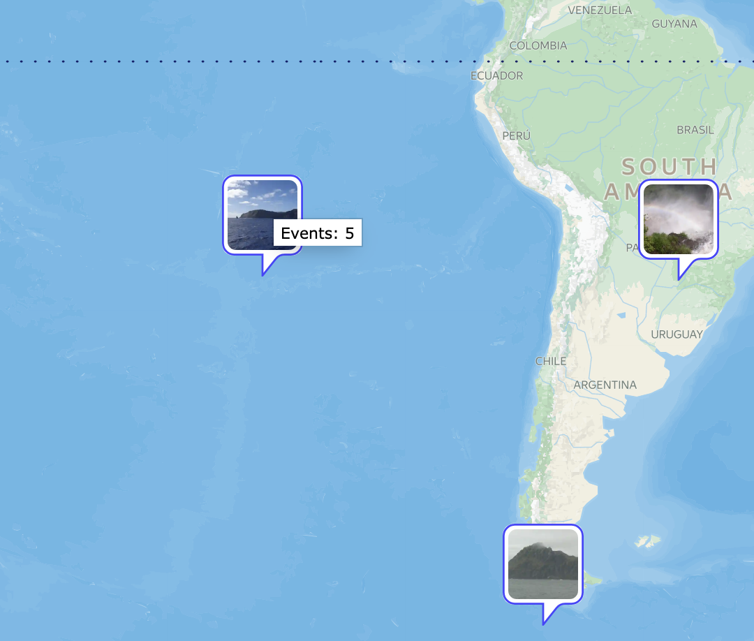
        • Go to the map and reproduce the view like the one on the last screenshot. It is important to make sure this image is on the wrong location, like here. If for some reason it will be in correct location, all further steps are useless.
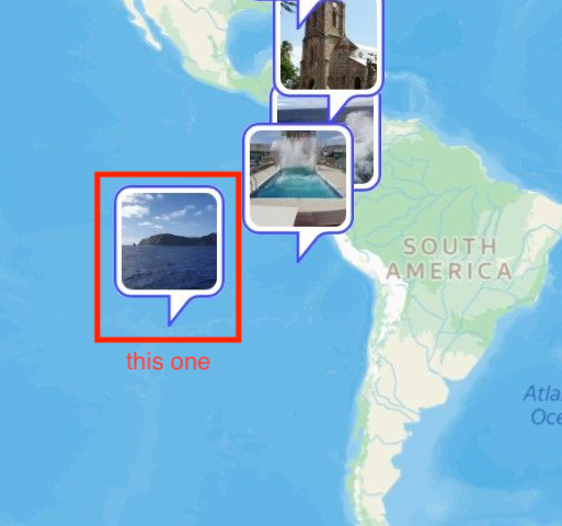
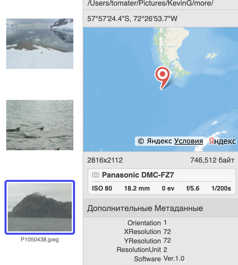
        • Doubleclick on that image with a hill in the ocean.
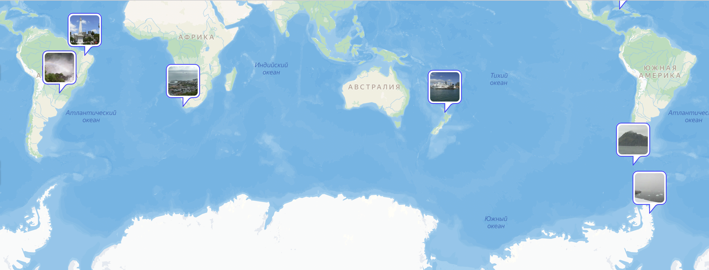
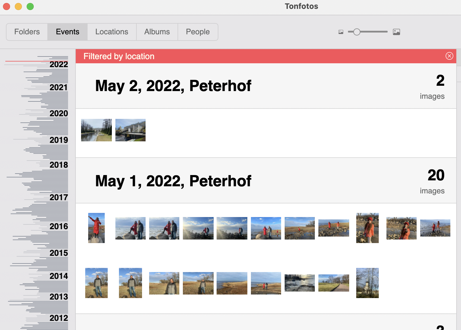
        • This will bring you to events view with one or more events selected. If there will be several events selected, you will see red stripe like on the image below (“Filtered by location” on top). If there will be only one image, there will be no red stripe like that.
        • Then please write back to me what do you see. If there is no red stripe, what is the name of the event then?
        • If there are other events, then please share on dropbox files from those events too.

        I hope this will help us figure out what is going wrong.

        Have uploaded images of hill on ocean, no Antarctica there or any other icons and two images of the files that show on that icon WC stands for World Cruise
        .

        Interesting, I did this in Geotag app and it showed all in correct position, have uploaded geotag screenshot

          KevinG Thanks a lot! Finally, I can see the same issue at my computer. I will dig into it.

            Andrey At the closer look though, this again does not look as the problems at all. What seemed to be wrongly put into the middle of the ocean, actually is Easter island, which is indeed in the middle of the ocean, as it should be. So, this is totally legit pin on the map.

            Now I think I have to ask you again, what exactly seems to be the problem with the pins on the map in Tonfotos? Everything that seemed off to me we have already checked and it turned out that that this is not that off. So I need some more direction to understand where to dig further. Can you please point specific pins on your screenshots that do not seem legit?

            Please keep in mind that due to grouping, it is OK if some pins disappear on larger zoom, as they become merged into other pins. This is totally normal. You can just zoom in a bit and they will appear again. This is not only feature of Tonfotos. All applications will map feature function same way. The screenshot from other application you added confirms exactly that - they have more pins for Antarctic, but Easter island photos are completely gone from their view. As you can see, they do completely the same thing, though their grouping algorithm might be a little different.

            6 days later

            Dear KevinG, it looks like we did not get anywhere with this one, unfortunately. I feel bad that you are not totally satisfied with Tonfotos. However, this bug hunting using exchanging screenshots does not seem to be very efficient. What do you think if we have video call with remote desktop sharing to get to bottom of this much faster?

            12 days later

            Antarctica location and South America now working.
            I have done a complete relocation to a USB drive (130,000 pics), rescanning took days as expected, took over a hour for the last “few seconds left” to scan. Had a few crashes and now after completing scan it has started scanning again. Files on USB not changed.
            Is there a way to stop rescan?

              KevinG you don’t need to stop rescan. Tonfotos regularly rescans all connected sources, but it basically checks for changes only. This process may take time, but it does not take a lot of resources and does not prevent you from working with Tonfotos as if there is no rescan at all. Basically, you just ignore it. You don’t even need to wait for it to finish and just close program when you done.

              As to hunting down locations issue - my proposal to have a video call still on the table.

              Write a Reply...